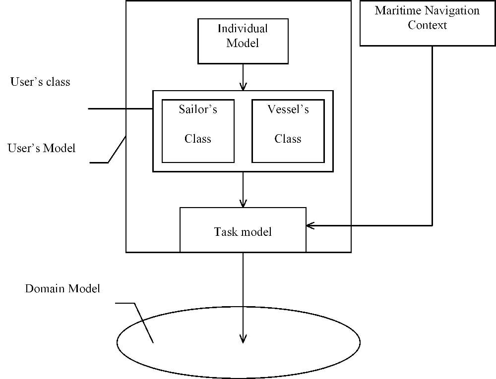
Fig. 1 User's Modelling (full size)
S. Garlatti1, S. Iksal1, P. Kervella2
1 Laboratoire IASC, ENST
Bretagne, ZI de Kernevent, BP 832,
29285 BREST Cedex , France, Tel : 33 2 98 00 14 53, Fax : 33 2 98 00
10 30,
Email : Serge.Garlatti@enst-bretagne.fr
http ://www-iasc.enst-bretagne.fr/~garlatti
2 Atlantide, Technopôle Brest Iroise, Site du Vernis,
CP n°2, 29608 Brest Cedex, France
Abstract: SWAN project (Adaptive and Navigating Web Server) aims to design adaptive web servers for on-line multimedia information systems about nautical publications. It is a joined project between the IASC laboratory and a private company called Atlantide. The project is funded by the west region council and supported by the French naval hydrographic and oceanographic service. In on-line information systems, users used to only access a fragment of information space according to their current goal. User's goals can provide navigation help [1-8]. In our framework, user modelling is based on stereotypes and more precisely on prototypical user's tasks and on user's class. It also uses a domain model, an individual user's model and the navigation context features. The content and presentation adaptation is achieved by the user's class. The task model is used to design navigation processes, to define views of hyperspace. The task model structures the information access to make the navigation easier. A task determines the relevant domain concepts available in a particular geographical area - due to the structural organisation of nautical publications. The goals of adaptation, adaptation technologies, user features, strategy to define spatial views depend on the current task.
Keywords : on-line information system, adaptive web server, user modeling, task model, domain model.
SWAN project aims to design an adaptive web server for on-line information systems about nautical publications by means of user modelling. First of all, we present the SWAN project and its requirements. Secondly, user modelling and task model are introduced. Thirdly, we go into details about two particular users's goals. In conclusion some discussions and perspectives are considered.
The on-line information system will provide nautical information available in different types of publications for different classes of sailors and vessels to prepare a maritime navigation or to navigate on oceans. In order to acquire users' goals and how they achieve them with paper publications, we made free and directed interviews of some different categories of sailors - military, shipping, commerce and yachtsman. This study showed that sailors have a common set of goals which are stables and are achieved in very similar way. Nevertheless, some of them have special goals related to their particular trade - for instance vessels which lay underwater cables for telecommunications or hydrographic vessels. We also investigated nautical publications for acquiring domain knowledge. In the first version of the web server, we decided to study these common goals, named services. Task analysis of services showed that it is quite natural to represent them by a hierarchical task model [10]. According to this study, a task model is used for user modelling.
Some aspects of the current version of this on-line information system is intentionally simple. Indeed, all future users don't make a habit of utilising computer-based systems to achieve their daily tasks. Consequently, it is important to firstly design a software which is not too far from the current software in nautical domain. The purpose of the first version is also to show the benefits of adaptive on-line information systems to sailors, to acquire new goals for the systems and to suggest sailor propositions and comments before going further. For the same reason, the task model is masked to the users. Now, we present user modelling enabling us to design the adaptive web server.
Fig. 1 User's Modelling (full size)
The user's model is composed of a user's class, a task model and an individual model. Its structure is similar to the user's model of Hynecosum [2]. The user's class consists of a sailor's class and a vessel's class. The former has only one feature, the sailor category which can be professional or yachtsman. The vessel's class features are the following : length, breadth, height, tonnage, draught, navigation category which determines maximal distances from a shelter, vessel type (military, fishing, cargo, yacht, ..). The maritime navigation context consists of a set of navigation condition features : tide, time, weather forecast, general inference, GPS position (Lat/Long) or position chosen by the sailor. The user's individual model enables the sailor to choose an adaptation method for a particular task or to specify some parameters of an adaptation method and to choose the minimal depth of route. Some tasks have a default adaptation method which is annotation. It's possible for a user to choose hiding or partial hiding instead of annotation.
According to Brusilosky, content-level and link-level, called respectively adaptive presentation and adaptive navigation support, are the two main classes of hypermedia adaptation [5]. The sailor's class is used for adaptive presentation and the task model for adaptive navigation. At present, the content and presentation adaptation is achieved in a simple way - for the first version : it depends on the sailor's category: professional or yachtsman ; sailing directions are different for these two user's classes. Adaptive presentation is processed in the same way whatever the task. Adaptive navigation support is achieved by means of a task model which uses the vessel's class, an individual model and the navigation context. Indeed, all tasks are available for each sailor's class. In a next version, we could design specific tasks for particular sailor's classes.
According to interviews, we find out four common goals for sailors - named Services - that are sufficiently general and high-level to be stable : route retrieval or creation, route information retrieval, port / anchorage, general information retrieval. Route retrieval or creation helps the sailor to find a route from a port/anchorage to another one. Route information retrieval provides navigation information, regulations, aids to navigation, lights, dangers to navigation, local conditions, currents, ... according to the route chosen. Port / anchorage gives to the sailor information about port entry, anchorage, marinas, facilities, services, etc., and a port retrieval based on the available services in the port and around. General information retrieval provides history of weather, geography, oceanography, country and so on.Determining a view of hyperspace - the relevant information space - according to a user's goal and then offering a small hyperspace to the user in which he can browse. A view, called a spatial view, is an information space which is composed of the data belonging to the domain of a particular geographical area. Communicating with the users to get some parameters or data, Providing the different " steps " of navigation in a certain context - current goal, Defining the adaptation method and its parameters.
Task analysis of services showed that it is quite natural to represent
them by a hierarchical task model [10].
In our model, we have two kinds of tasks : abstract and atomic.
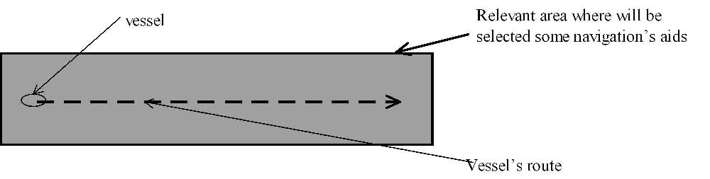
The domain model determines the domain concepts and their relationships which are well-known for advanced and expert sailors. The relevant domain concepts associated to a task specify a hyperspace view which is not sufficiently small. Indeed, the sailor may browse the relevant concepts of all geographical areas. We need to reduce the information space to that is useful according to the vessel's position by means of a spatial view. It is an information space which is composed of the data belonging to the relevant concepts of a particular geographical area. A geographical area can be represented by a polygon on a chart. It depends on the considered concepts and tasks. For some concepts, it corresponds to a sailing direction's area. For navigation aids, it corresponds to a smaller polygon defined a priori or be the results of a computation. It is always included into a sailing direction area. In other words, a spatial view selects the useful data according to the vessel's position and the user's task (cf. fig. 2).

Fig 2. Hyperspace views providing by different parts of the user model (full size).
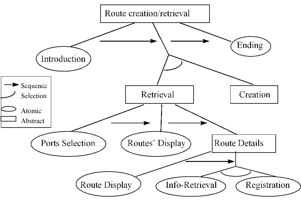
Fig. 3. Graph of the " Route Creation/Retrieval " service (full size)
Each service begins with an introduction task to explain the service's goals and a ending task to close it, mainly for tutorial aspects of the first version. Then the users may choose between the retrieval task or the creation. Whether retrieval task has been chosen and no route has been selected, the user can select the creation task to design a new route. The " Ports Selection " task enables the user to choose two ports/anchorage, " Routes' display " find out the corresponding routes and display the result with an default adaptive method. The user may choose a route and get details about it and maybe want to get route information before validating his choice. The system does not place restriction on port/anchorage choices about maritime regulations or sailor's skills. Whether the route is non-relevant or forbidden, an explanation is provided to the sailor. Annotation as default adaptive method was chosen because the sailors prefer it and it enable us to explain the reasons to sailors.
In " Route Creation/Retrieval " service the relevant domain concepts are defined by the sub-graph root, named " route object " which possesses the following sub-concepts " way-points ", " route section " and " route ". A route is composed of several route sections which are defined by two way-points, a compass course, a route section type (inshore traffic area, offshore traffic area, landfall, port entry), a minimal depth, a length, a sailing direction area, danger conditions. A route possesses some other attributes like: a departure and an arrival port/anchorage, a route category, a minimal depth, a length and advisable or not.
By means of the departure and arrival port/anchorage, the task retrieves the routes between the two locations and associates to each route a state. There are four possible states: advisable, secure, non secure and forbidden. The route states are computed from the vessel's class features (draught, navigation category, vessel type), the individual model (minimal depth) and navigation context features (tide, tidal streams, time). The default adaptive navigation method is the annotation based on these states. But the user will be able to choose between annotation and hiding - one or more route states - by means of the individual model or could be suggested by the system.
The four annotation states are computed as follows: i) forbidden route: wrong vessel's type, wrong route's category, minimal depth less than the vessel's draught or the user's minimal depth ; ii) non secure route: permitted route, port/anchorage non-allowed for the vessel, due to draught, tonnage or size, forecast an tide conditions leading to dangerous route ; iii) secure route : minimal depth equal or greater than that required by the sailor, permitted route ; iv) advisable route, a secure route which is advised in sailing directions.
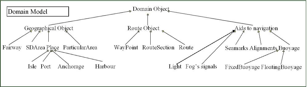
Fig. 4. Domain model (full size)
A spatial view - an information space - depends on the categories and the route section type. It is composed of the data belonging to the relevant concepts of a particular geographical area. A geographical area can be represented by a polygon on a chart. This area depends on route section type for a given category. For a given concept - lights, buoyage, seamarks, fog signals or alignments -, the relevant data are obtained by a filtering process defined by means of the geographical area which reduces the information space to the useful data. We mainly focus on the " aids to navigation " category to highlight the different way of defining spatial views.
In figure 5, the " Route Information Retrieval " service is described. The " Route selection " task is available to the sailor whether he has not previously chosen a route in the " Route Retrieval/Creation " service. Then, he can access the " Retrieval " sub-task to select a route. The " Route Information Retrieval " service is also accessed from the " Route Creation/Retrieval " service, when the sailor has a look for routes' details.
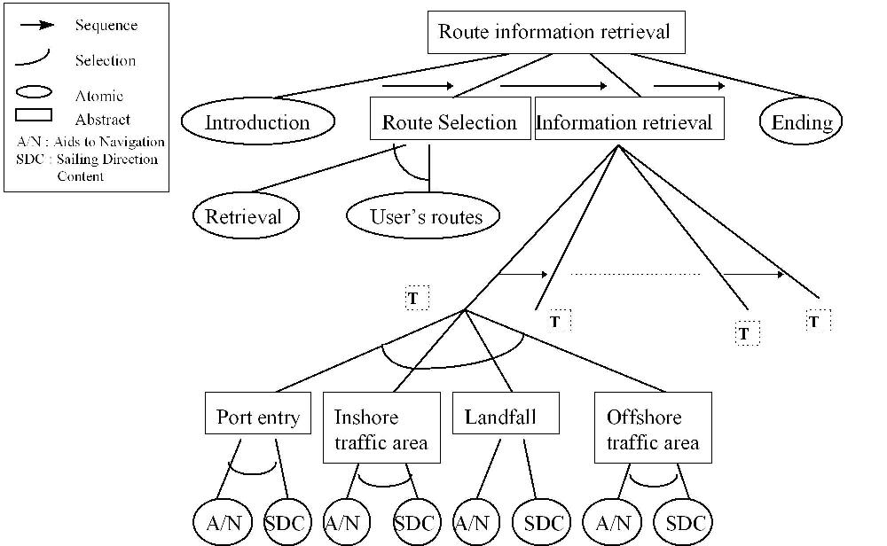
Fig. 5 Graph of the " Route Information Retrieval " service (full size)
Now, we go into details about the " Information Retrieval " task. This task is composed of a sequence of sub-tasks, one task per route section type. A particular task class is associated with each route section type. Each class is composed of two sub-tasks, one per category " aids to navigation " or " sailing direction content " to define the corresponding strategy for spatial views and adaptive method.
In a task, a sailor can access the sub-graph corresponding to navigation's aids. Each relevant leaf is annotated with a specific color and non-relevant one with another color. Concept annotation is based on the weather and time features : fog or not -, day or night. Relevant concepts are computed as follows :
The computation of the geographical area uses the notion of visibility.
It takes into account the range and the angular sector of the navigation's
aid - angular geographical area where the element is visible regardless
of its range -. According to the task class, all visible elements are selected
or only those which are visible and available in a particular polygon.
The system must consider the three following case :
All elements which are in the relevant area and are visible from the vessel are selected. All the elements are ordered according to the course section: the nearest is in first, the furthest in last. The sailor can choose an element and gets its features (text, images, ...) and its orientation according to the route section - North, East, South, West, North-East, ...).
The second class is composed of seamarks and alignments (with or without lights). All elements, visible from the vessel, are selected. They are sorted by direction according to the course section: North, North-West, North-East, South, South-East, West, East.
The task model has been designed from interviews. But, the system is a new tool and consequently the task model is not based on a real user's task. It was necessary to design new tasks which are extended from the current user's behaviours with paper publications. We need to check and improve the task model. At present the task model is masked to the users because we assume that the user's background is insufficient to deal with the complexity of the task model, its modifications and its design. But maybe, it is important to enable some users to manage the task model and to create new tasks.
In the next stage, we plan to add some features in our adaptive web server : extending user's preferences for adapting dynamically the task model, adapting the relevant zone of a route section which gives us the visible buoys, the strategy to choose the seamarks, finer user's classes - more user's classes -, .... We plan to adapt the server to the user's knowledge as well as his domain knowledge than his hypermedia's knowledge. But we need to evaluate the current version before modifying in order to take into account the user's comments. Indeed, when a new tool is designed it is difficult to get the user's preferences or needs. Then, it is necessary to design a first version with which it is possible to get a new tool, closer to the user's needs.
2. Vassileva, J., A Task-Centered Approach for user Modeling in a hypermedia Office Documentation system. User Models and User Adapted Interaction, 1996(6): p. 185-223.
3. Höök, K., et al., A glass box approach to adaptive hypermedia. User Models and User Adapted Interaction, 1996(6).
4. Encarnação, L.M., Adaptivity in graphical user interface: an experimental framework. Computers & graphics, 1995. 19(6): p. 873-884.
5. Brusilovsky, P., Methods and techniques of adaptive hypermedia. User Modeling and User-Adapted Interaction, 1996. 6(2-3): p. 87-129.
6. Grunst, G., Adaptive hypermedia for support systems, in Adaptive user interfaces: Principles and Practice, M. Schneider-Hufschmidt, T. Küme, and U. Malinnowski, Editors. 1993, North-Holland: Amsterdam. p. 269-283.
7. Tyler, S.W. and S. Treu, An interface architecture to provide Adaptive Task-Specific Context for the user. International Journal of Man, Machine and Studies, 1989(30): p. 303-327.
8. Kaplan, C., J. Fenwick, and J. Chen, Adaptive Hypertext Navigation Based on User Goals and Context. User modelling and user adapted interaction, 1993. 3(2): p. 193-220.
9. Conklin, J., Hypertext: An introduction and Survey. IEEE Computer, 1987.
10. Rasmussen, J., A. Pejtersen, and L. Goodstein, Cognitive system Engineering. 1994, New York: John Wiley & Sons.
11. Rich, E., Stereotypes and user modeling, in user models in dialog systems, A. Kobsa and W. Wahlster, Editors. 1989, Springer verlag: berlin. p. 35-51.
12. Kobsa, A., User modeling: Recent Work, Prospects and Hazards, in Adaptive User Interfaces: Principles and Practice, M. Schneider-Hufschmidt, T. Kühme, and U. Malinowski, Editors. 1993, Notrh-Holland: Amsterdam.
13. Kay, J. Lies, Damned Lies and Stereotypes: Pragmatic approximations of users. in Conference on user modeling. 1994: Hyannis, MA: p. 175-184.
14. Apple, WebObjects, . 1997, Apple Computer.
15. MacGregor, R.M. A Description Classifier for the Predicate Calculus.
in Proceedings of the Twelfth National Conference on Artificial Intelligence.
1994: p. 213-220,.